
Processing of earth observation data to increase accessibility and and reduce barriers for their use
Background
The agricultural sector was and is subject to change. The mechanisation, the introduction of pesticides and fertilisers and new insights into plant genetics have triggered leaps of innovation. Currently, agriculture is on the verge of another revolution. Modern devices such as sensors placed in a field, or attached to machines, analyses tools for large datasets (i.e., machine learning, Big Data) and data from satellites are already available. Therefore, decisions about the amount of fertilisers and pesticides to be used, the best time for irrigation, and the distribution of seeds can be based on data from different sources.
Project-Content
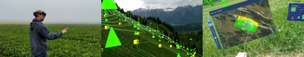
The digitalisation of agriculture is expected to be an important cornerstone in establishing highly efficient and sustainable production systems. For instance, the EU's Earth Observation Programme Copernicus Sentinel offers a broad range of different satellite data at for free. However, farmers often lack the necessary background knowledge to make sense of this kind of data. They are unexperienced in systematically storing, organizing and using such information properly. ARmEO aims to address this issue. The project partners from the University of Natural Resources and Life Sciences use machine learning to extract relevant information from satellite data. In a second step this information is made accessible in a user-friendly way with the help of augmented and mixed reality devices and novel techniques for visualizing data. To this end we will explore the possibilities offered by different devices (i.e., smartphones and tablets and augmented reality- or smart glasses such as the Microsoft Hololens).
Project goals
The main aim of ARmEO’s is to make Copernicus Sentinel data easily accessible, thereby reducing barriers for users. Ways to create a user-friendly and cost-efficient interface between smart satellite-based tools and Augmented Reality (AR) technologies will be explored. This will facilitate data usage and allow precise monitoring and management of crop production.
The focus of the project is on target-oriented problems such as crop performance, optimization of nitrogen fertilization and irrigation, field scouting and field data collection. In the long run, other sectors could also benefit from Earth observation (EO) data, the AR visualization technologies and high precision navigation devices applied in the project (e.g., construction industry).
The main goals of the ARmEO project are:
- Advancing existing satellite-based products and making their data easily accessible by providing them in a user-friendly way (in accordance with regulations and policies).
- Investigating how Augmented Reality visualization technologies can be used to communicate Earth observation information to the user (i.e, with data provided by the Copernicus services which is processed by machine learning and visualized on site) .
Both activities are carried out on the basis of a user-centred approach.
Results
ARmEO provides relevant information when and where it is most needed by using high precision localisation and streaming the processed data to devices such as smart glasses. This lays the foundation for efficient workflows, helps to minimize risks and as a consequence increases productivity. Farmers are able to optimise the use of water and nitrogen, to improve coordination of work steps and deepen their knowledge about field conditions and potential threats. This strengthens their ability to successfully cope with current and future challenges (e.g. weather extremes caused by climate change) and make them more competitive in the long run.
Further Information on the Project
ARmEO | Augmented Reality meets Earth Observation
You want to know more? Feel free to ask!
Department of Media and Digital Technologies
Manuel Schumach
- BOKU Universität für Bodenkultur Wien (lead)
- AGROservice
- create4D