Increased data availability: Better understanding through visualization
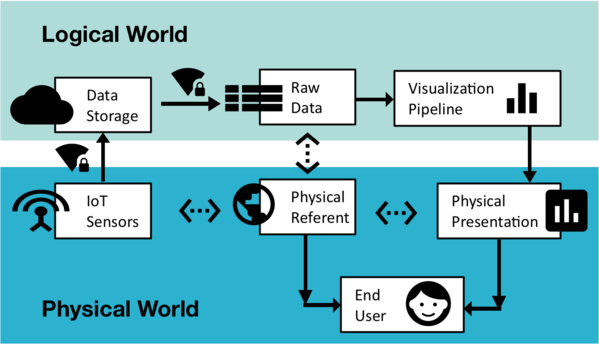
The amount and complexity of available data is constantly increasing. This wealth of data opens up new possibilities for technical progress and economic success. Since data per se are not visible to humans and are therefore difficult to integrate into the environment of problem solving, data visualization is needed. This means transforming data into images in order to make the information easily accessible. Generally, however, such visualizations are completely independent of their physical environment and are not designed to make data visible and usable in the real world environment.
Sensor data
In addition to classic business and administrative data, sensor data have enormously gained importance in recent years. This means for example data on soil or air quality, chemical composition, temperature, water level, humidity or position coordinates. Acquiring and especially transmitting and consolidating these measurements depend on technical infrastructures such as power supply and (radio) network coverage. In rural areas, however, these technical prerequisites are often not or only insufficiently available. Promising technologies for solving these problems are so-called "Low-Power Wide Area Networks" (LPWAN), which can record and transmit sensor data over long distances with extremely low energy consumption.
Project content
"Dataskop" breaks new scientific ground developing mobile, situational embedded data visualization methods to combine physical environmental and abstract data representation. Proof-of-concept prototypes for low-cost LPWAN kits are developed, which can be used to construct outdoor sensor networks. In order to protect the data transmission in the networks from manipulation and abuse, IT security methods are developed, tested and prototypically implemented. An open data management platform is developed to collect sensor data and serve as standardized interface. In addition, economic models are being developed. Through this holistic and interdisciplinary approach, the vision of a Sensor-Based Data Economy in Lower Austria can be realized, leading to Smart Rural Areas.
Method & Use Cases
The scientific-technical results of the project are designed to be application-independent. This means that the methods and concepts developed are applicable in a large number of different areas. In order to prove specific applicability of the results and to validate the scientific results, concrete use cases are employed. They focus on outdoor use without well-developed digital infrastructures.
In particular questions relating to the following topics are addressed:
- Disaster management (e.g. flood protection on smaller water bodies)
- Public services and infrastructure (e.g. winter services, drinking water supply)
- Tourism (e.g. air quality, measurement data related to leisure activities such as swimming pools)
Using synergies
This project is made possible by the fact that Lower Austrian Higher Education institutions have expertise across the entire technology chain from the collection of data (sensor technology, data infrastructure - FOTEC and Danube University Krems) their processing (visualization, IT Security - St. Pölten University of Applied Sciences) and their use (Business Value Creation, Business Process Transformation - IMC University of Applied Sciences Krems).
You want to know more? Feel free to ask!
- IMC Fachhochschule Krems
- FOTEC FH Wiener Neustadt
- UWK Universität für Weiterbildung Krems, Department für Integrierte Sensorsysteme (DISS)


